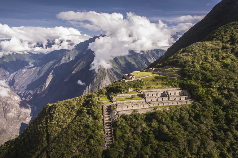
The Choquequirao Trek 4-Day Itinerary is a classic out-and-back high-mountain route that cuts deep into the canyon of the Apurímac River before climbing up to the cloud-forest ridge where the archaeological complex stands at 3,050 meters. Spanning approximately 64 kilometers (40 miles) round-trip, this trail demands steady pacing and tactical hydration.
Day-by-Day Trail Breakdown
Day 1: Cusco – Capuliyoc – Chiquisca – Playa Rosalina
Distance: 19 km | Elevation Change: +100m / -1,500m | Hiking Time: 5 to 6 hours
We depart Cusco early in private transport across the Anta plains and Limatambo valley, reaching the Capuliyoc trailhead at 2,900 meters. After packing gear onto our mule caravan, the hike begins with a spectacular view across the canyon toward snowcapped Padreyoc. The trail plunges steeply downward on dusty switchbacks through the semi-arid canyon wall. We pause at Chiquisca (1,900m) for fresh shade and lunch before continuing down to Playa Rosalina on the banks of the roaring Apurímac River at 1,500 meters, where we set up camp under warm canyon skies.
Day 2: Playa Rosalina – Santa Rosa – Marampata
Distance: 13 km | Elevation Change: +1,400m / -50m | Hiking Time: 5 to 6 hours
This is the physical crucible of the trek. We cross the pedestrian suspension bridge over the Apurímac River at dawn before the sun heats the rock faces. The trail ascends relentlessly up steep zigzagging switchbacks to the rustic settlement of Santa Rosa (2,100m), where fresh sugarcane juice is available. We continue climbing past bromeliads and scrub oak to the plateau of Marampata (2,870m). Here, high-altitude Andean breezes replace canyon heat, and the distant western terraces of Choquequirao come into view across the gorge.
Day 3: Marampata – Full Exploration of Choquequirao – Chiquisca
Distance: 16 km | Elevation Change: +350m / -1,300m | Hiking Time: 7 to 8 hours
We head out at first light to explore the ancient citadel of Choquequirao (3,050m) before any mid-day haze settles over the valley. Unlike crowded Machu Picchu, you will share these vast stone complexes with only a handful of hikers. We inspect the Main Plaza, the ceremonial Hanan sector, the Priest’s quarters, the sacred fountains, and the iconic white-stone llama mosaic terraces built into the sheer hillside. After an intensive guided tour, we return to Marampata for lunch and descend back down the switchbacks across the river to camp at Chiquisca (1,900m).
Day 4: Chiquisca – Capuliyoc Pass – Cusco
Distance: 16 km | Elevation Change: +1,000m / -50m | Hiking Time: 4 to 5 hours
To avoid the scorching midday sun of the canyon walls, we start climbing at 5:00 AM from Chiquisca back up toward Capuliyoc. The morning shade keeps body temperatures comfortable on the continuous uphill grade. Reaching the Capuliyoc viewpoint (2,900m) offers a rewarding backward look over the entire canyon traverse. After a celebratory farewell lunch with our muleteers, our private transport brings us back to Cusco by mid-afternoon.
Elevation Profile & Route Metrics
Waypoint
Altitude
Terrain Type
Key Highlights
Capuliyoc Trailhead
2,900 m (9,514 ft)
Dirt ridge road
Viewpoint, mule loading, trailhead checkpoint
Playa Rosalina
1,500 m (4,921 ft)
Canyon floor riverbed
Apurímac suspension bridge, warm camp
Marampata Plateau
2,870 m (9,416 ft)
Grassland plateau
Lodge huts, cold drinks, views of Choquequirao
Choquequirao Ruins
3,050 m (10,006 ft)
Ancient stone architecture
Llama terraces, Hanan Plaza, Cloud forest ruins
Official Mountain Expedition
Ready to Conquer the Apurímac Canyon & Choquequirao?
Trek 4 days into the last Inca citadel with licensed mountain guides, pack mules, 4-season camps, and certified WAFA wilderness first responders.