Trek Overview: The Classic Inca Trail 4 Days / 3 Nights spans 43 km (26.7 miles) along ancient pre-Columbian stone staircases from Piscacucho (Km 82) to the Sun Gate (Inti Punku) overlooking Machu Picchu. Operated directly by Inka Jungle Tour under official MINCETUR license in Cusco, our expeditions feature regulated SERNANP government permits (strictly limited to 500 people per day including trail crew), alpine mountain campsites with 4-season dual-occupancy tents, private chef, WAFA-certified porters, and licensed mountain guides.
The Classic Inca Trail covers 43 kilometers (26.7 miles) across centuries-old stone stairways linking the Sacred Valley to the high jungle. Designed as a four-day wilderness traverse, this route tests cardiovascular endurance with elevations ranging from 2,400 meters (7,874 feet) up to the mountain crest of Dead Woman’s Pass (Warmiwañusqa) at 4,215 meters (13,828 feet). Walking this ancient trail is not merely an athletic expedition; it is a step-by-step progression through sacred geography that prepared Inca royalty and pilgrims for entering the citadel.
If your travel schedule is compact or you prefer sleeping in a hotel rather than wilderness camps, you can select the Short Inca Trail 2 Days, which captures the highlights and the entrance through the Sun Gate in a fast-paced format.
🗺️ Technical Route Breakdown by Stage
Pacing is everything on the Inca Trail. A frequent misstep among first-time trekkers is pushing too fast on day one and arriving depleted for the high pass. Below is the operational reality of each stage so you can budget your physical stamina accurately.
Trail Distance & Elevation Profile:
| Day | Section (Camp to Camp) | Distance / Hiking Time | Max Elevation |
|---|---|---|---|
| Day 1 | Piscacucho (Km 82) to Wayllabamba | 12 km (6-7 hrs) | 3,000 m (9,842 ft) |
| Day 2 | Wayllabamba to Pacaymayo (via Warmiwañusqa) | 11 km (7-8 hrs) | 4,215 m (13,828 ft) |
| Day 3 | Pacaymayo to Wiñay Wayna (via Runkurakay) | 16 km (8-9 hrs) | 3,950 m (12,959 ft) |
| Day 4 | Wiñay Wayna to Inti Punku & Machu Picchu | 4 km (2 hrs) | 2,720 m (8,923 ft) |
🎒 Day 1: Valley Warm-up (Km 82 to Wayllabamba)
The expedition starts at Piscacucho (Km 82), where park rangers cross-check every passport against official SERNANP permit lists. Day one offers an approachable introduction to the Andean terrain. The trail follows the course of the Urubamba River with rolling undulations (“Andean flat”) and gentle climbs. It is the ideal window to adjust trekking poles, find your stride, and adapt to moderate altitude.
The visual centerpiece of this section is the archaeological complex of Patallacta (Llaqtapata). Rather than rushing past, our guides halt here to examine the agricultural terraces and residential quarters that provisioned travelers en route to Machu Picchu.
Trail Tip: Do not underestimate this gentle opening stage. Hydrate steadily throughout the day with electrolyte water. Dehydration accumulated on day one will punish your legs tomorrow morning on the steep stone ascent.
🦶 Day 2: The Vertical Crucible of Dead Woman’s Pass
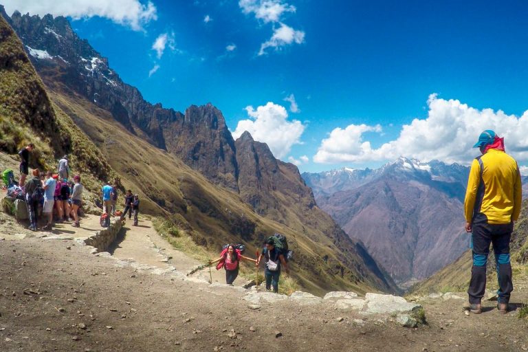
Day two delivers the primary physical test of the entire trek. An early wake-up call at 5:00 AM with hot coca tea prepares you for the climb up Warmiwañusqa Pass. The trail rises relentlessly through shifting microclimates, climbing out of Polylepis cloud forests into the open, wind-swept Andean puna.
At 4,215 meters (13,828 feet), oxygen levels drop noticeably. Speed is counterproductive here; rhythm is everything. Maintain a steady, measured pace—one step, one exhale. Crossing the pass opens sweeping views of snowcapped peaks before descending steep, uneven stone stairs into the Pacaymayo valley camp. To understand how to train for these stairs, review our guide on Inca Trail difficulty and fitness preparation.
🌱 Day 3: Cloud Forest Traverse & Ancient Ruins
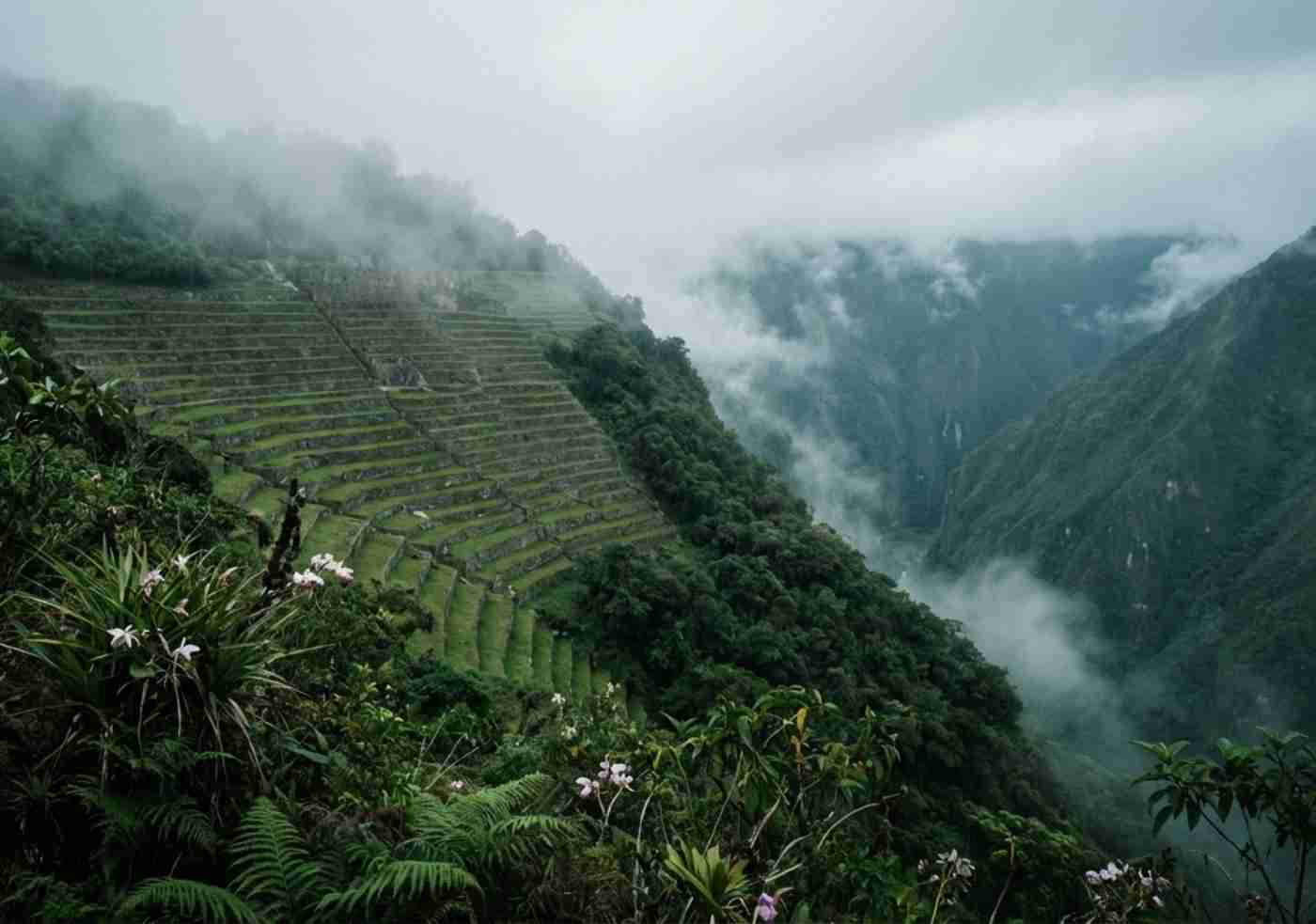
For veteran hikers, day three is the most rewarding scenic stretch. Leaving the dry puna behind, the path plunges into the high jungle (“Ceja de Selva”). The trail surmounts a second pass at Runkurakay (3,950 m) before revealing the circular watchtower of the same name and the cliffside citadel of Sayacmarca.
Bromeliads, wild orchids, and hummingbirds flank the moss-draped stone causeways. The route passes through an Inca-carved rock tunnel and crosses Phuyupatamarca (“City in the Clouds”) before tackling a sustained stone staircase descent to Wiñay Wayna (“Forever Young”). This magnificent hillside terraced city serves as our final camp, set in warm, subtropical air.
☀️ Day 4: Triumphant Sunrise at Inti Punku & Machu Picchu
The final morning begins at 3:30 AM to clear the checkpoint and reach the Sun Gate (Inti Punku) as dawn breaks over the Andes. The 4 km hike winds along gentle cliffside trails before a final 50-step vertical stone stairway (“the monkey steps”) brings you to the threshold of Inti Punku.
From this elevated vista, the entire stone citadel of Machu Picchu reveals itself below in quiet morning light—an exclusive vantage point reserved solely for Inca Trail hikers. Following a comprehensive 2-hour guided circuit through the ruins, hikers descend to Aguas Calientes. You can walk down the restored stone stairs (approximately 1.5 hours) or take the optional Consettur shuttle bus (+$12 USD one-way).
- Expedition Specifications:
- Total Distance: 43 km (26.7 miles)
- Highest Elevation: 4,215 m (13,828 ft) at Warmiwañusqa Pass
- Lowest Elevation: 2,400 m (7,874 ft) at Machu Picchu
- Terrain: Ancient stone stairways, packed mountain dirt, granite tunnels
- Weather: Intense equatorial sun by day, freezing sub-zero temperatures at night
- Permits: Mandatory government quotas (must be booked 6 months ahead)
✅ The Best Part: Sweeping ecological transitions from glacial passes to lush cloud forest in a single day, crowned by the sunrise entrance through Inti Punku.
❌ The Challenge: Wilderness facilities are basic, and long stone staircase descents on day three require trekking poles to spare knee joints.
Safety & Mountain Medical Protocol:
In remote valleys like Pacaymayo and Runkurakay, cellular reception does not exist. Our guides carry satellite communication radios and certified medical oxygen kits to manage acute altitude symptoms immediately, backed by clear evacuation procedures.
📅 Plan Your Trek Well Ahead
The Classic Inca Trail cannot be booked on short notice. Government permits sell out months in advance. Once you confirm your travel window, securing official permits is the single most urgent step. Check our comprehensive packing guide on what to pack for the Inca Trail to prepare your gear correctly.
📅 Book your Classic Inca Trail 4-Day trek here before permits sell out.
Ready to hike? Check live dates and book your Classic Inca Trail 4 Days with licensed local guides.